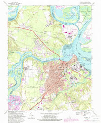
1969 Map of Hopewell
USGS Topo · Published 1987About this map
Bermuda Hundred and City Point anchor the confluence of the James River and Appomattox River, serving as critical historical nodes in this late 1960s landscape. The map captures a high-density industrial and residential period in Hopewell, where chemical and manufacturing plants cluster near the riverfront alongside the Petersburg National Battlefield. To the south, the extensive grounds of Fort Lee Military Reservation contrast with the emerging suburban subdivisions of Kenwood and Arlington.
Find a feature on this map
101 named features on this map. Tap any name to fly to it.
Don’t see what you’re looking for? This feature index may not catch every label — zoom into the map to look around manually.
Map Details
Editions of this 1969 Hopewell Map
4 editions found
Other maps of this area

1894 · Bermuda Hundred
USGS Topo · 1:62,500

1894 · Petersburg
USGS Topo · 1:62,500

1918 · Charles City
USGS Topo · 1:62,500

1919 · Disputanta
USGS Topo · 1:62,500

1938 · Dutch Gap
USGS Topo · 1:24,000

1938 · Drewrys Bluff
USGS Topo · 1:24,000

1943 · Dutch Gap
USGS Topo · 1:31,680

1943 · Hopewell
USGS Topo · 1:31,680

1943 · Disputanta
USGS Topo · 1:31,680

1943 · Richmond
USGS Topo · 1:250,000