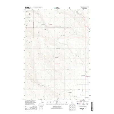
2013 Map of Hopper Creek
USGS Topo · Published 2013About this map
Payette National Forest dominates the northwestern section of this Idaho landscape, where the Hitt Mountains rise sharply above the drainage basins. The area is defined by a dense network of watercourses and deep ravines, most notably Hopper Cr and the Keithly Cr system. To the southeast, the terrain softens into the Shoe Peg Valley, a name that likely reflects the local ranching or agricultural heritage of Washington County. A complex system of unpaved forest and ranch roads, such as Cow Camp Rd and Keithly Creek Rd, provides access across this varied topography. Small-scale features like Looney Spring and distinctive landmarks such as Two Tree Gulch and Advent Gulch offer precise reference points for those tracing historical land use or original property boundaries in this mountainous Idaho interior.
Find a feature on this map
29 named features on this map. Tap any name to fly to it.
Don’t see what you’re looking for? This feature index may not catch every label — zoom into the map to look around manually.
Map Details
Editions of this 2013 Hopper Creek Map
This is the sole edition of this map. No revisions or reprints were ever made.
Other maps of this area

1897 · Weiser
USGS Topo · 1:125,000

1953 · Mann Creek
USGS Topo · 1:62,500

1955 · Baker
USGS Topo · 1:250,000

1957 · Cambridge
USGS Topo · 1:62,500

1957 · Crane Creek Reservoir
USGS Topo · 1:62,500

1957 · Sturgill Peak
USGS Topo · 1:62,500

1959 · Baker
USGS Topo · 1:250,000

1980 · McCall
USGS Topo · 1:100,000

1980 · Weiser
USGS Topo · 1:100,000
1986 · Midvale
USGS Topo · 1:24,000