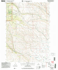
2004 Map of Hopper Creek
USGS Topo · Published 2007About this map
The Hitt Mountains and the western reaches of the Payette National Forest dominate this Idaho-Washington borderland. The landscape is defined by a dense network of drainages including Hopper Creek, West Pine Creek, and the winding Keithly Creek. In the lower elevations, agricultural and ranching markers appear, such as a Feed Lot and Corral near the southern boundary.
Find a feature on this map
23 named features on this map. Tap any name to fly to it.
Don’t see what you’re looking for? This feature index may not catch every label — zoom into the map to look around manually.
Map Details
Editions of this 2004 Hopper Creek Map
This is the sole edition of this map. No revisions or reprints were ever made.
Other maps of this area

1897 · Weiser
USGS Topo · 1:125,000

1953 · Mann Creek
USGS Topo · 1:62,500

1955 · Baker
USGS Topo · 1:250,000

1957 · Cambridge
USGS Topo · 1:62,500

1957 · Crane Creek Reservoir
USGS Topo · 1:62,500

1957 · Sturgill Peak
USGS Topo · 1:62,500

1959 · Baker
USGS Topo · 1:250,000

1980 · McCall
USGS Topo · 1:100,000

1980 · Weiser
USGS Topo · 1:100,000
1986 · Midvale
USGS Topo · 1:24,000