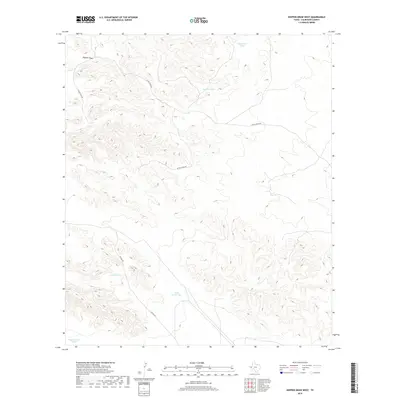
2019 Map of Hopper Draw West
USGS Topo · Published 2019About this map
Hopper Draw carves a path through this Culberson County landscape, illustrating the critical role of water management in West Texas. This 2019 survey captures a network of livestock or industrial watering points, including Sink Hole Tank, Pipeline Tank, and Veal Tank, which are scattered across the terrain to support ranching operations. The road network is sparse but functional, centered on the transit provided by Elcor-Toyah Rd and Foster Rd. The systematic placement of sites like Tank Number One and Tank Number Three reflects the careful organization of land and resources in a high-desert environment. This sheet is particularly useful for researchers studying modern land use, grazing patterns, or local infrastructure in this part of the Trans-Pecos.
Find a feature on this map
9 named features on this map. Tap any name to fly to it.
Don’t see what you’re looking for? This feature index may not catch every label — zoom into the map to look around manually.
Map Details
Editions of this 2019 Hopper Draw West Map
This is the sole edition of this map. No revisions or reprints were ever made.
Other maps of this area

1928 · Kent
USGS Topo · 1:125,000

1954 · Van Horn
USGS Topo · 1:250,000

1958 · Van Horn
USGS Topo · 1:250,000
1970 · East Hunter Canyon
USGS Topo · 1:24,000
1970 · Panther Canyon
USGS Topo · 1:24,000
1970 · Iron Mountain
USGS Topo · 1:24,000

1973 · Dellahunt Draw West
USGS Topo · 1:24,000
1973 · Dome Hill
USGS Topo · 1:24,000
1973 · Dellahunt Draw East
USGS Topo · 1:24,000
1973 · Hopper Draw East
USGS Topo · 1:24,000