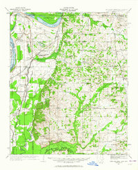
1932 Map of Horn Lake
USGS Topo · Published 1964About this map
Horn Lake and the oxbows of the Mississippi River define the landscape of this delta borderland in the early 1930s. The region is marked by a dense network of local landmarks, including Howards Store and Wilson Store, which served as rural community hubs alongside numerous churches like Bethlehem Ch and Mt Zion Ch. The Mississippi And Illinois Central RR tracks provide the primary transportation spine through the western alluvial plain, connecting settlements such as Lake Cormorant and Norfolk.
Find a feature on this map
100 named features on this map. Tap any name to fly to it.
Don’t see what you’re looking for? This feature index may not catch every label — zoom into the map to look around manually.
Map Details
Editions of this 1932 Horn Lake Map
3 editions found
Other maps of this area

1908 · Hollywood
USGS Topo · 1:24,000

1908 · Lake Cormorant
USGS Topo · 1:24,000

1912 · Lake Cormorant
USGS Topo · 1:31,680

1913 · Hollywood
USGS Topo · 1:31,680

1916 · Memphis
USGS Topo · 1:62,500

1925 · Memphis
USGS Topo · 1:48,000

1927 · Memphis
USGS Topo · 1:62,500

1931 · Horseshoe Lake
USGS Topo · 1:62,500

1932 · Horn Lake
USGS Topo · 1:48,000

1932 · Crenshaw
USGS Topo · 1:62,500