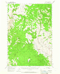
1957 Map of Hornet
USGS Topo · Published 1965About this map
The Payette National Forest dominates this mid-century landscape where the border of Adams and Washington counties meets. The terrain is defined by the drainage of the Weiser River and Crooked River, punctuated by high-elevation lookout points like Peck Mtn Lookout and Point Lookout. This era shows a transition in the local infrastructure; the presence of the Hornet Ranger Sta indicates active forest management, while several local educational landmarks, including Upper Dale School and Ridge Sch, are already marked as abandoned.
Find a feature on this map
92 named features on this map. Tap any name to fly to it.
Don’t see what you’re looking for? This feature index may not catch every label — zoom into the map to look around manually.
Map Details
Editions of this 1957 Hornet Map
3 editions found

Other maps of this area

1911 · Meadows
USGS Topo · 1:125,000

1920 · Seven Devils Mining District
USGS Topo · 1:48,000

1938 · Riggins
USGS Topo · 1:96,000

1945 · Riggins
USGS Topo · 1:125,000

1954 · Council
USGS Topo · 1:62,500

1954 · New Meadows
USGS Topo · 1:62,500

1955 · Baker
USGS Topo · 1:250,000

1955 · Grangeville
USGS Topo · 1:250,000

1957 · Cambridge
USGS Topo · 1:62,500

1957 · Cuprum
USGS Topo · 1:62,500