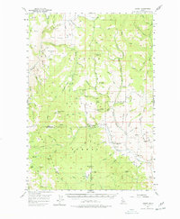
1957 Map of Hornet
USGS Topo · Published 1978About this map
Payette National Forest dominates this mid-century landscape in the Idaho backcountry, where the transition from high-elevation lookouts to river valleys is clearly defined. The terrain is marked by remote industrial and administrative outposts, such as the Hornet Ranger Sta and the North Hornet Mine, showing the dual reliance on forest management and mineral extraction. Higher peaks like Cuddy Mountain overlook a complex network of creeks and gulches, including Bear Creek Falls and the West Fork Weiser River. Local history is captured in the presence of former educational sites like the Upper Dale School (Aban'd) and Ridge Sch (Aban'd), both noted as abandoned by the late 1950s. This pattern of settlement suggests a retreating rural population as once-active mountain schools and mines gave way to managed wilderness and seasonal recreational areas like Johnson Creek Park.
Find a feature on this map
85 named features on this map. Tap any name to fly to it.
Don’t see what you’re looking for? This feature index may not catch every label — zoom into the map to look around manually.
Map Details
Editions of this 1957 Hornet Map
3 editions found

Other maps of this area

1911 · Meadows
USGS Topo · 1:125,000

1920 · Seven Devils Mining District
USGS Topo · 1:48,000

1938 · Riggins
USGS Topo · 1:96,000

1945 · Riggins
USGS Topo · 1:125,000

1954 · Council
USGS Topo · 1:62,500

1954 · New Meadows
USGS Topo · 1:62,500

1955 · Baker
USGS Topo · 1:250,000

1955 · Grangeville
USGS Topo · 1:250,000

1957 · Cambridge
USGS Topo · 1:62,500

1957 · Cuprum
USGS Topo · 1:62,500