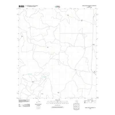
2010 Map of Horse Camp Waterhole
USGS Topo · Published 2010About this map
Bundy-Ross Ranch and the Jackson Ranch represent the sprawling ranching operations found throughout this portion of Kerr County during the early twenty-first century. The landscape is defined by its seasonal water management, where named catchments like Valentine Tank, Goat Tank, and Cedar Tank provide essential resources for livestock in a territory carved by intermittent drainages. Topographical features such as Beasley Draw, Lydle Draw, and Wildcat Draw channel drainage toward larger watercourses like Paint Creek and Hunger Creek. The distribution of scattered infrastructure, including Sampson Windmill, Paint Creek Windmill, and Deer Leg Windmill, reflects the practical needs of remote land management. These individual landmarks, along with the namesake Horse Camp Waterhole, provide specific points of reference for genealogists and researchers studying the modern agricultural footprint and land-use patterns of the Texas Hill Country.
Find a feature on this map
17 named features on this map. Tap any name to fly to it.
Don’t see what you’re looking for? This feature index may not catch every label — zoom into the map to look around manually.
Map Details
Editions of this 2010 Horse Camp Waterhole Map
This is the sole edition of this map. No revisions or reprints were ever made.
Other maps of this area

1926 · Segovia 2-c
USGS Topo · 1:48,000

1932 · Junction
USGS Topo · 1:62,500

1954 · Llano
USGS Topo · 1:250,000

1955 · Llano
USGS Topo · 1:250,000

1956 · Llano
USGS Topo · 1:250,000

1963 · Garven Store
USGS Topo · 1:24,000

1963 · Y O Ranch
USGS Topo · 1:24,000
1971 · Bradford Creek
USGS Topo · 1:24,000
1971 · Earwood Creek
USGS Topo · 1:24,000
1971 · Horse Camp Waterhole
USGS Topo · 1:24,000