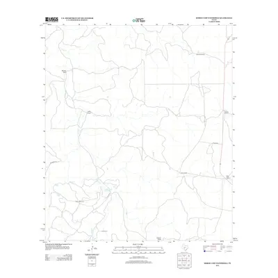
2012 Map of Horse Camp Waterhole
USGS Topo · Published 2012About this map
Horse Camp Waterhole and a series of livestock tanks anchor this rangeland landscape in Kerr County, reflecting a local economy tied to water access and cattle ranching. The map illustrates a network of essential infrastructure, including family-named sites like the Bundy-Ross Ranch and Jackson Ranch. Windmills such as the Sampson Windmill and Deer Leg Windmill are vital markers for navigation and survival in this terrain, situated near ephemeral water sources like Paint Cr and Hunger Cr. This modern survey documents the persistent ranching layout where features like Lydle Draw and Beasley Draw define the movement of water across the land. Small water catchments including Goat Tank and Valentine Tank are scattered throughout, highlighting the necessary adaptations for managing livestock in a region defined by its drainage patterns and intermittent creek beds.
Find a feature on this map
21 named features on this map. Tap any name to fly to it.
Don’t see what you’re looking for? This feature index may not catch every label — zoom into the map to look around manually.
Map Details
Editions of this 2012 Horse Camp Waterhole Map
This is the sole edition of this map. No revisions or reprints were ever made.
Other maps of this area

1926 · Segovia 2-c
USGS Topo · 1:48,000

1932 · Junction
USGS Topo · 1:62,500

1954 · Llano
USGS Topo · 1:250,000

1955 · Llano
USGS Topo · 1:250,000

1956 · Llano
USGS Topo · 1:250,000

1963 · Garven Store
USGS Topo · 1:24,000

1963 · Y O Ranch
USGS Topo · 1:24,000
1971 · Bradford Creek
USGS Topo · 1:24,000
1971 · Earwood Creek
USGS Topo · 1:24,000
1971 · Horse Camp Waterhole
USGS Topo · 1:24,000