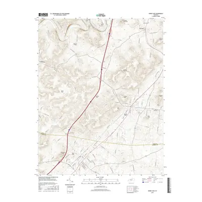
2016 Map of Horse Cave
USGS Topo · Published 2016About this map
Horse Cave and Cave City anchor this 2016 survey, sitting along the intersection of the CSX railroad and the modern highway corridor. The landscape is defined by the unique karst topography of south-central Kentucky, evidenced by prominent depressions like London Pace Sink and numerous named high points such as Vial Knob and Huckleberry Knob. To the north, the Green River carves distinctive loops at Mansfield Bend and Lawler Bend, while the smaller Creacy Lake sits east of the main settlements. The map traces the boundary between Hart Co and Barren Co, showing a mix of established town grids and agricultural land accessed by family-named routes like Logsdon Valley Cemetery Rd. This era shows the mature development of these cave-country gateway towns, where historic railroad routes and modern interstates converge near the small community of Rowletts.
Find a feature on this map
93 named features on this map. Tap any name to fly to it.
Don’t see what you’re looking for? This feature index may not catch every label — zoom into the map to look around manually.
Map Details
Editions of this 2016 Horse Cave Map
This is the sole edition of this map. No revisions or reprints were ever made.
Other maps of this area

1922 · Mammoth Cave
USGS Topo · 1:62,500

1923 · Mammoth Cave
USGS Topo · 1:62,500

1925 · Cub Run
USGS Topo · 1:62,500

1934 · Munfordville
USGS Topo · 1:48,000

1935 · Horse Cave
USGS Topo · 1:48,000

1937 · Munfordville
USGS Topo · 1:62,500

1938 · Horse Cave
USGS Topo · 1:62,500

1953 · Munfordville
USGS Topo · 1:24,000
1953 · Canmer
USGS Topo · 1:24,000

1954 · Evansville
USGS Topo · 1:250,000