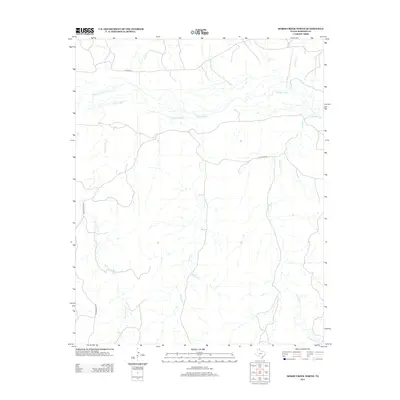
2012 Map of Horse Creek North
USGS Topo · Published 2012About this map
The Canadian River cuts through the northern section of this Roberts County landscape, defining the local hydrology and ranching topography. The terrain is marked by an extensive network of drainage channels including Horse Cr and Home Ranch Cr, which flow toward the river through a region historically significant for large-scale Texas Panhandle ranching operations. Traces of this heritage are visible in the naming of features such as Pickett Ranch Cr and Three Corrals Cr, reflecting the functional layout of the land for cattle management. McMordie Lake provides a localized water source in the central-southern portion of the quadrangle. Transportation is limited to rural ranch routes like Payne Ranch Rd and N River Rd, which follow the natural contours of the river valley and creek basins.
Find a feature on this map
11 named features on this map. Tap any name to fly to it.
Don’t see what you’re looking for? This feature index may not catch every label — zoom into the map to look around manually.
Map Details
Editions of this 2012 Horse Creek North Map
This is the sole edition of this map. No revisions or reprints were ever made.
Other maps of this area

1954 · Perryton
USGS Topo · 1:250,000

1954 · Amarillo
USGS Topo · 1:250,000

1958 · Perryton
USGS Topo · 1:250,000

1958 · Amarillo
USGS Topo · 1:250,000

1971 · Dry Creek SE
USGS Topo · 1:24,000

1971 · Dry Creek NE
USGS Topo · 1:24,000

1972 · Washburn Arroyo
USGS Topo · 1:24,000

1972 · Horse Creek North
USGS Topo · 1:24,000

1972 · East Dry Creek
USGS Topo · 1:24,000
1972 · Horse Creek South
USGS Topo · 1:24,000