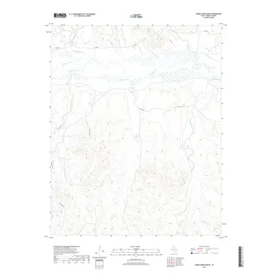
2019 Map of Horse Creek North
USGS Topo · Published 2019About this map
The Canadian River cuts a wide, braided path through this section of Roberts County, shaping a landscape defined by expansive ranch lands and deeply carved drainages. Numerous seasonal waterways, including Three Corrals Creek and Pickett Ranch Creek, feed into the river valley from the surrounding breaks. This 2019 survey by the U.S. Geological Survey highlights the sparse infrastructure of the Panhandle, where travel is limited to unpaved routes like Payne Ranch Rd and N River Rd. Significant local landmarks include McMordie Lake and various named drainages such as Home Ranch Cr and Hackberry Cr, which reflect the area's long history of cattle ranching and land use. The topography reveals the complex erosion patterns typical of the Canadian River basin, offering a detailed view of the terrain as it existed in the late 2010s.
Find a feature on this map
14 named features on this map. Tap any name to fly to it.
Don’t see what you’re looking for? This feature index may not catch every label — zoom into the map to look around manually.
Map Details
Editions of this 2019 Horse Creek North Map
This is the sole edition of this map. No revisions or reprints were ever made.
Other maps of this area

1954 · Perryton
USGS Topo · 1:250,000

1954 · Amarillo
USGS Topo · 1:250,000

1958 · Perryton
USGS Topo · 1:250,000

1958 · Amarillo
USGS Topo · 1:250,000

1971 · Dry Creek SE
USGS Topo · 1:24,000

1971 · Dry Creek NE
USGS Topo · 1:24,000

1972 · Washburn Arroyo
USGS Topo · 1:24,000

1972 · Horse Creek North
USGS Topo · 1:24,000

1972 · East Dry Creek
USGS Topo · 1:24,000
1972 · Horse Creek South
USGS Topo · 1:24,000