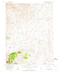
1957 Map of Horse Creek Valley
USGS Topo · Published 1963About this map
The Cortez Mts and Simpson Park Mts anchor this high-desert landscape in central Nevada, where the 1950s ranching and mining infrastructure is meticulously recorded. The terrain is a complex arrangement of dry basins and mountain ranges, with Horse Creek Valley and Garden Valley providing the primary corridors for travel along the Cortez-Beowawe Road. Evidence of mineral exploration is scattered throughout the northern slopes, notably at the Buckhorn Mine and several unnamed prospects and tunnels near the peaks.
Find a feature on this map
56 named features on this map. Tap any name to fly to it.
Don’t see what you’re looking for? This feature index may not catch every label — zoom into the map to look around manually.
Map Details
Editions of this 1957 Horse Creek Valley Map
2 editions found

Other maps of this area

1926 · Roberts Mountains
USGS Topo · 1:250,000

1929 · Roberts Mountains
USGS Topo · 1:250,000

1937 · Mineral Hill
USGS Topo · 1:48,000

1938 · Cortez
USGS Topo · 1:48,000

1943 · Mineral Hill
USGS Topo · 1:62,500

1944 · Cortez
USGS Topo · 1:62,500

1949 · Garden Valley
USGS Topo · 1:62,500

1949 · Crescent Valley
USGS Topo · 1:62,500

1949 · Roberts Creek Mtn
USGS Topo · 1:62,500

1950 · Crescent Valley
USGS Topo · 1:62,500