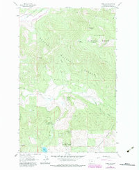
1963 Map of Horse Hill
USGS Topo · Published 1984About this map
Horse Hill and its Lookout Tower command the center of this mountain landscape within the Kootenai National Forest and Flathead National Forest. This 1963 survey, photorevised in the early 1980s, captures the remote drainage basins of Wolf Creek and Little Wolf Creek before extensive modern development. The northwest corner is defined by the Burlington Northern railroad corridor as it follows the curve of the water through the valley, while higher elevations like Sheppard Mountain and Tepee Mountain are marked by an established Pack Trail. Toward the southern edge of the sheet, Island Lake and Surprise Hill provide clear reference points for those tracing historical land use or timber boundaries. The map reflects a moment in time when the national forest infrastructure relied heavily on these high-altitude lookout points and rugged transit routes.
Find a feature on this map
15 named features on this map. Tap any name to fly to it.
Don’t see what you’re looking for? This feature index may not catch every label — zoom into the map to look around manually.
Map Details
Editions of this 1963 Horse Hill Map
2 editions found
Other maps of this area

1920 · Jennings
USGS Topo · 1:125,000

1935 · Thompson Lakes
USGS Topo · 1:96,000

1942 · Thompson Lakes
USGS Topo · 1:125,000

1957 · Kalispell
USGS Topo · 1:250,000

1960 · Kalispell
USGS Topo · 1:250,000

1961 · Kalispell
USGS Topo · 1:250,000

1963 · Wolf Prairie
USGS Topo · 1:24,000

1963 · Warland Peak
USGS Topo · 1:24,000

1963 · Sylvia Lake
USGS Topo · 1:24,000
1963 · Bowen Lake
USGS Topo · 1:24,000