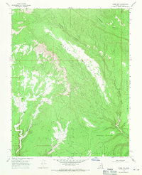
1968 Map of Horse Mtn
USGS Topo · Published 1971About this map
Horse Mountain dominates this corner of Kane County, part of a high-desert landscape defined by prominent plateau levels and deeply incised drainage systems. In the late 1960s, the area remained largely undeveloped, characterized by wide elevations such as Paradise Bench and Squaw Bench that drop away into the complex network of Escalante Canyon and Paradise Canyon. The geography reflects the necessity of water in this arid environment, with specific labels marking reliable points like Tommy Water and Fourmile Water. Human access at the time was limited to a rudimentary Jeep Trail, which winds through the terrain to connect these isolated water sources and benches. The transition from the high plateau of Fourmile Bench down through Fourmile Canyon illustrates the dramatic verticality of the region's sedimentary layers before the widespread modern mapping of the Utah backcountry.
Find a feature on this map
15 named features on this map. Tap any name to fly to it.
Don’t see what you’re looking for? This feature index may not catch every label — zoom into the map to look around manually.
Map Details
Editions of this 1968 Horse Mtn Map
2 editions found
Other maps of this area

1886 · Escalante
USGS Topo · 1:250,000

1922 · Upper Last Chance
USGS Topo · 1:63,360

1956 · Escalante
USGS Topo · 1:250,000

1960 · Escalante
USGS Topo · 1:250,000

1964 · Horse Flat
USGS Topo · 1:24,000

1964 · Canaan Peak
USGS Topo · 1:24,000

1964 · Death Ridge
USGS Topo · 1:24,000

1964 · Carcass Canyon
USGS Topo · 1:24,000
1964 · Butler Valley
USGS Topo · 1:24,000

1968 · Fourmile Bench
USGS Topo · 1:24,000