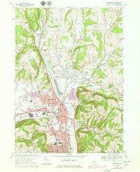
1978 Map of Horseheads
USGS Topo · Published 1979About this map
Horseheads and Elmira Heights serve as the commercial and industrial anchors of this Chemung County landscape during the late 1970s. The valley floor is a dense corridor of transportation and industry, defined by the Conrail lines and the winding course of Newtown Creek. Notable civic and social hubs include the County Fairgrounds, the Army and Navy Reserve Center, and several local schools like Ridge Road Sch and the Center St Sch.
Find a feature on this map
67 named features on this map. Tap any name to fly to it.
Don’t see what you’re looking for? This feature index may not catch every label — zoom into the map to look around manually.
Map Details
Editions of this 1978 Horseheads Map
2 editions found
Other maps of this area

1893 · Ithaca
USGS Topo · 1:62,500

1895 · Ithaca
USGS Topo · 1:62,500

1895 · Elmira
USGS Topo · 1:62,500

1898 · Watkins Glen
USGS Topo · 1:62,500

1901 · Watkins
USGS Topo · 1:62,500

1902 · Waverly
USGS Topo · 1:62,500

1905 · Watkins Glen
USGS Topo · 1:125,000

1950 · Elmira
USGS Topo · 1:250,000

1950 · Alpine
USGS Topo · 1:24,000

1950 · Montour Falls
USGS Topo · 1:24,000