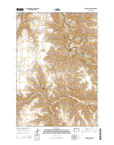
2014 Map of Horseshoe Bend
USGS Topo · Published 2014About this map
McInnes Norton Ridge and Wolf Mtn dominate the high ground of this section along the Sherman and Gilliam County border. The landscape is defined by an intricate network of drainage systems, including the namesake Horseshoe Bend in the northeast and deeply carved features such as Hannafin Canyon and Armstrong Canyon. Water sources are critical points on this arid terrain, with Hatley Springs, McInnes Spring, and Stakely Spring scattered throughout the central and southern reaches. This modern survey illustrates the persistent importance of natural landmarks and seasonal water in the high desert. Local routes like Dobie Point Ln and McInnis Rd provide access to cattle country and higher elevations such as Adobe Point, while the southern area features topographic landmarks including North Pole Ridge and Guyton Canyon.
Find a feature on this map
38 named features on this map. Tap any name to fly to it.
Don’t see what you’re looking for? This feature index may not catch every label — zoom into the map to look around manually.
Map Details
Editions of this 2014 Horseshoe Bend Map
This is the sole edition of this map. No revisions or reprints were ever made.
Other maps of this area

1916 · Condon
USGS Topo · 1:125,000

1953 · The Dalles
USGS Topo · 1:250,000

1956 · The Dalles
USGS Topo · 1:250,000

1957 · The Dalles
USGS Topo · 1:250,000
1970 · Chimney Springs
USGS Topo · 1:24,000

1970 · Indian Cove
USGS Topo · 1:24,000

1970 · Kent
USGS Topo · 1:24,000

1970 · Macken Canyon
USGS Topo · 1:24,000
1970 · Shoestring Ridge
USGS Topo · 1:24,000

1970 · Rosebush
USGS Topo · 1:24,000