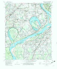
1960 Map of Horseshoe Lake
USGS Topo · Published 1982About this map
Large oxbow lakes and sprawling plantation grounds dominate this Delta landscape at the transition of the 1950s. The curving waters of Horseshoe Lake and Porter Lake illustrate the historic migrations of the Mississippi River, creating a complex network of bayous and sloughs. The agrarian character of the era is evidenced by named properties like the Belle Meade Plantation, Columbia Plantation, and Snowden Plantation, reflecting a landscape of large-scale agriculture supported by numerous small community hubs.
Find a feature on this map
136 named features on this map. Tap any name to fly to it.
Don’t see what you’re looking for? This feature index may not catch every label — zoom into the map to look around manually.
Map Details
Editions of this 1960 Horseshoe Lake Map
2 editions found
Other maps of this area

1908 · Hollywood
USGS Topo · 1:24,000

1908 · Lake Cormorant
USGS Topo · 1:24,000

1912 · Lake Cormorant
USGS Topo · 1:31,680

1913 · Hollywood
USGS Topo · 1:31,680

1916 · Memphis
USGS Topo · 1:62,500

1925 · Memphis
USGS Topo · 1:48,000

1927 · Memphis
USGS Topo · 1:62,500

1931 · Horseshoe Lake
USGS Topo · 1:62,500

1932 · Horn Lake
USGS Topo · 1:48,000

1932 · Crenshaw
USGS Topo · 1:62,500