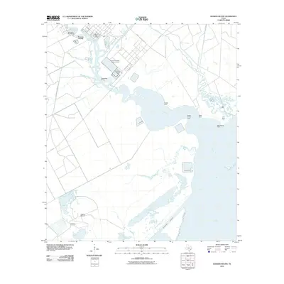
2010 Map of Hoskins Mound
USGS Topo · Published 2010About this map
Hoskins Mound rises above the coastal wetlands of Brazoria County, providing a high-ground anchor in a landscape defined by meandering bayous and expansive salt marshes. This 2010 survey captures the industrial and maritime character of the Texas Gulf Coast, where the Amoco Chemical Company and its massive Amoco Chemicals Reservoir Levee occupy a significant footprint near the river bends. The map traces the winding course of Chocolate Bayou as it empties into Chocolate Bay, a critical transition zone between the inland marshes and the open waters of West Bay. Evidence of local recreation and transport is found at Peterson Landing and the Horseshoe Bend Marina, while the Intracoastal Waterway cuts a straight path through the lower reaches of the map, serving as a primary artery for coastal shipping and commerce.
Find a feature on this map
23 named features on this map. Tap any name to fly to it.
Don’t see what you’re looking for? This feature index may not catch every label — zoom into the map to look around manually.
Map Details
Editions of this 2010 Hoskins Mound Map
This is the sole edition of this map. No revisions or reprints were ever made.
Other maps of this area

1929 · Karankawa Lake
USGS Topo · 1:24,000

1929 · Hitchcock
USGS Topo · 1:24,000

1932 · Hitchcock
USGS Topo · 1:31,680

1932 · Mustang Bayou
USGS Topo · 1:31,680

1933 · Karankawa Lake
USGS Topo · 1:31,680

1933 · San Luis Pass
USGS Topo · 1:31,680

1943 · San Luis Pass
USGS Topo · 1:31,680

1943 · Oyster Creek
USGS Topo · 1:31,680

1943 · Danbury
USGS Topo · 1:31,680

1943 · Mustang Bayou
USGS Topo · 1:31,680