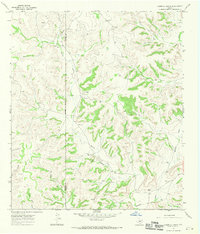
1967 Map of Hospital Ranch
USGS Topo · Published 1970About this map
The dry, dissected Edwards Plateau landscape of West Texas is defined here by a network of ranching outposts and drainage draws. Sparse vegetation and a reliance on subterranean water sources are evident through the naming of family-run operations such as Hospital Ranch, Glasscock Ranch, and Red Mill Ranch. The terrain is deeply incised by a series of ephemeral watercourses including Willow Draw, Granger Draw, and Plum Canyon, which dictate the placement of local roads and livestock infrastructure. Scattered Gravel Pits and a Drill Hole point to the extraction of natural resources in a region primarily dedicated to pastoral use. This survey also captures the intersection of several political boundaries, where Crockett Co and Glasscock Co meet at a point near the Berger Ranch.
Find a feature on this map
27 named features on this map. Tap any name to fly to it.
Don’t see what you’re looking for? This feature index may not catch every label — zoom into the map to look around manually.
Map Details
Editions of this 1967 Hospital Ranch Map
2 editions found
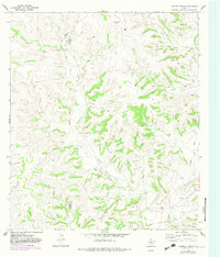
Other maps of this area

1954 · Sonora
USGS Topo · 1:250,000

1958 · Sonora
USGS Topo · 1:250,000

1967 · Nolen Draw
USGS Topo · 1:24,000

1967 · Savell Ranch
USGS Topo · 1:24,000

1967 · Ozona SE
USGS Topo · 1:24,000

1967 · Shafter Draw
USGS Topo · 1:24,000

1967 · Crockett Heights
USGS Topo · 1:24,000

1967 · Hudspeth Draw
USGS Topo · 1:24,000

1967 · Caverns Of Sonora
USGS Topo · 1:24,000

1969 · Wild Horse Canyon
USGS Topo · 1:24,000