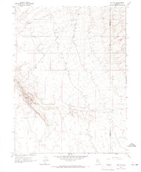
1965 Map of Hot Pot
USGS Topo · Published 1967About this map
Geothermal features define this high-desert landscape along the border of Humboldt Co and Lander Co. The map is centered on the distinct terrain of the Hot Pot, a name given to a specific geothermal mound located just north of the Hot Springs. This area represents a characteristic Great Basin environment where water sources are critical landmarks for navigation and survival. Apart from the central springs, the presence of a Well and routes leading to the Izzenhood Ranch and the Hot Springs Ranch suggest a landscape organized around isolated ranching outposts. The topographic detail captures the arid basin's varied elevations, providing an essential record of the local water resources and infrastructure as they existed in the mid-1960s, prior to significant modern development in the region.
Find a feature on this map
8 named features on this map. Tap any name to fly to it.
Don’t see what you’re looking for? This feature index may not catch every label — zoom into the map to look around manually.
Map Details
Editions of this 1965 Hot Pot Map
2 editions found
Other maps of this area

1882 · Paradise
USGS Topo · 1:250,000

1893 · Paradise
USGS Topo · 1:250,000

1932 · Sonoma Range
USGS Topo · 1:250,000

1939 · Sonoma Range
USGS Topo · 1:250,000

1955 · McDermitt
USGS Topo · 1:250,000

1955 · Winnemucca
USGS Topo · 1:250,000

1958 · Winnemucca
USGS Topo · 1:250,000

1959 · McDermitt
USGS Topo · 1:250,000

1962 · Winnemucca
USGS Topo · 1:250,000

1965 · Knight
USGS Topo · 1:24,000