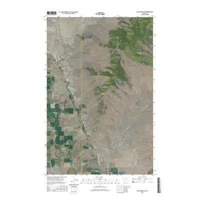
2017 Map of Hot Springs NE
USGS Topo · Published 2017About this map
Lonepine serves as a central reference point in this western Montana landscape where the plains meet the rising slopes of the Salish Mountains. The hydrology of the region is defined by the Little Bitterroot River, which winds through the valley floor, supported by several tributaries including Sullivan Cr and Dry Fork Cr. The presence of the Camas B Canal indicates the importance of managed water systems for the local agricultural community, while naming conventions like Rattlesnake Gulch and Garcon Gulch reflect the rugged topography that transitions from flat riverbed to high mountain ridges. Local transportation is grounded in a network of rural routes such as Hyre Rd and Garcon Gulch Rd, connecting isolated homesteads across the Lake and Sanders County line. This survey illustrates the spatial relationship between natural water sources and the grid-based development of the Montana interior during the early 21st century.
Find a feature on this map
30 named features on this map. Tap any name to fly to it.
Don’t see what you’re looking for? This feature index may not catch every label — zoom into the map to look around manually.
Map Details
Editions of this 2017 Hot Springs NE Map
This is the sole edition of this map. No revisions or reprints were ever made.
Other maps of this area

1920 · Flathead Lake
USGS Topo · 1:125,000

1956 · Wallace
USGS Topo · 1:250,000

1960 · Wallace
USGS Topo · 1:250,000

1964 · Irvine Lookout Tower
USGS Topo · 1:24,000

1964 · Mill Pocket Creek
USGS Topo · 1:24,000

1964 · Markle Pass
USGS Topo · 1:24,000

1964 · Lonepine
USGS Topo · 1:24,000

1964 · Hot Springs
USGS Topo · 1:24,000
1964 · Niarada
USGS Topo · 1:24,000
1964 · Hot Springs NE
USGS Topo · 1:24,000