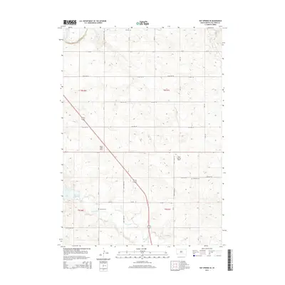
2015 Map of Hot Springs SE
USGS Topo · Published 2015About this map
Cheyenne River winds through the northwestern corner of this South Dakota landscape, part of a drainage network that includes the Angostura Reservoir and Horsehead Cr. The terrain is defined by its deep draws and coulees, notably Horse Camp Draw and Slate Spring Draw, which slice through the prairie. For genealogists and local historians, the map is a significant record of the rural landscape southeast of Hot Springs, identifying several burial grounds such as Smithwick Cem, Horsehead Cem, and Fairview Cem. A rectilinear grid of gravel and section roads like Lemon School Rd and Hidden Valley Rd provides the primary infrastructure for this ranching and agricultural country. The presence of named drainages like Sand Cr and Sunny Brook Rd reflects the importance of water management and local landmarks in this expansive Fall River County environment.
Find a feature on this map
31 named features on this map. Tap any name to fly to it.
Don’t see what you’re looking for? This feature index may not catch every label — zoom into the map to look around manually.
Map Details
Editions of this 2015 Hot Springs SE Map
This is the sole edition of this map. No revisions or reprints were ever made.
Other maps of this area

1896 · Oelrichs
USGS Topo · 1:125,000

1900 · Oelrichs
USGS Topo · 1:125,000

1950 · Hot Springs
USGS Topo · 1:24,000

1950 · Buffalo Gap
USGS Topo · 1:24,000

1950 · Hot Springs SE
USGS Topo · 1:24,000

1950 · Angostura Reservoir
USGS Topo · 1:24,000

1951 · Smithwick NW
USGS Topo · 1:24,000

1955 · Hot Springs
USGS Topo · 1:250,000
1982 · Smithwick
USGS Topo · 1:25,000
1982 · Lone Well Creek East
USGS Topo · 1:24,000