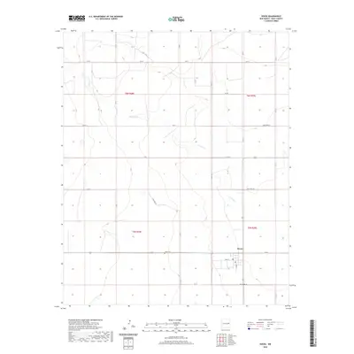
2020 Map of House
USGS Topo · Published 2020About this map
The settlement of House serves as the primary focal point in this portion of Quay County, situated at the intersection of several regional routes and local streets like Main St and S Ash St. The town's presence is defined by a grid-like arrangement of roads that contrast with the winding path of Alamosa Cr, which traverses the landscape from northwest to southeast. This drainage system provides a natural structure to the terrain, which is otherwise delineated by the rigid Public Land Survey System boundaries of t6n r28e, t6n r29e, t5n r28e, and t5n r29e.
Find a feature on this map
27 named features on this map. Tap any name to fly to it.
Don’t see what you’re looking for? This feature index may not catch every label — zoom into the map to look around manually.
Map Details
Editions of this 2020 House Map
This is the sole edition of this map. No revisions or reprints were ever made.
Other maps of this area

1954 · Fort Sumner
USGS Topo · 1:250,000

1954 · Clovis
USGS Topo · 1:250,000

1958 · Fort Sumner
USGS Topo · 1:250,000

1958 · Clovis
USGS Topo · 1:250,000

1968 · Hassell
USGS Topo · 1:24,000

1968 · Ima SE
USGS Topo · 1:24,000

1968 · Candy Mesa
USGS Topo · 1:24,000

1970 · Jordan
USGS Topo · 1:24,000
1970 · Cunavea Basin
USGS Topo · 1:24,000

1973 · House
USGS Topo · 1:24,000