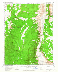
1957 Map of House Rock Spring
USGS Topo · Published 1964About this map
House Rock Spring and its surrounding high-desert terrain define this mid-century survey of the northern Arizona borderlands. Located within the Kaibab National Forest and the Grand Canyon National Game Preserve, the landscape is a complex network of canyons and washes where water management was critical to survival and ranching. The map reveals numerous small-scale engineering efforts, including Government Reservoir, Joes Reservoir, and the Deer Water Catchment.
Find a feature on this map
41 named features on this map. Tap any name to fly to it.
Don’t see what you’re looking for? This feature index may not catch every label — zoom into the map to look around manually.
Map Details
Editions of this 1957 House Rock Spring Map
3 editions found
Other maps of this area

1886 · Kanab
USGS Topo · 1:250,000

1886 · Escalante
USGS Topo · 1:250,000

1886 · Echo Cliffs
USGS Topo · 1:250,000

1886 · Kaibab
USGS Topo · 1:250,000

1891 · Echo Cliffs
USGS Topo · 1:250,000

1936 · Jacobs Lake
USGS Topo · 1:48,000

1940 · Jacob Lake
USGS Topo · 1:62,500

1953 · Jacobs Lake
USGS Topo · 1:62,500

1953 · Cedar City
USGS Topo · 1:250,000

1953 · Grand Canyon
USGS Topo · 1:250,000