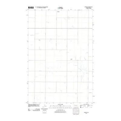
2011 Map of Hoving
USGS Topo · Published 2011About this map
The unincorporated community of Hoving anchors the northern reaches of this North Dakota prairie landscape, situated along the grid of agricultural section roads in Willey Township. The 2011 survey reveals a vast, open terrain marked by numerous small wetlands and drainage patterns that intersect the township's rectilinear road network. Local history and genealogy are preserved in two distinct sites: Zion Cemetery in the western half and Dunbar Cemetery toward the southeast. These burial grounds serve as significant landmarks within the agricultural grid, reflecting the early settlement patterns of Sargent County. Connectivity is maintained through a system of numbered routes like 135th Ave SE and 81st St SE, with County Hwy J providing a primary north-south artery through the eastern portion of the quadrangle.
Find a feature on this map
16 named features on this map. Tap any name to fly to it.
Don’t see what you’re looking for? This feature index may not catch every label — zoom into the map to look around manually.
Map Details
Editions of this 2011 Hoving Map
This is the sole edition of this map. No revisions or reprints were ever made.
Other maps of this area

1907 · Wyndmere
USGS Topo · 1:125,000

1953 · Fargo
USGS Topo · 1:250,000

1956 · Fargo
USGS Topo · 1:250,000

1958 · Rutland
USGS Topo · 1:24,000
1958 · Forman
USGS Topo · 1:24,000

1958 · Cayuga NW
USGS Topo · 1:24,000
1958 · Cayuga
USGS Topo · 1:24,000

1960 · Lisbon SE
USGS Topo · 1:24,000

1960 · Milnor
USGS Topo · 1:24,000
1962 · Hoving
USGS Topo · 1:24,000