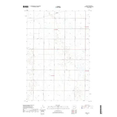
2018 Map of Hoving
USGS Topo · Published 2018About this map
Hoving sits in the northern portion of this Sargent County landscape, where the prairie is defined by a dense network of wetlands and small water bodies. The settlement pattern follows a rigid section-line grid of rural roads, including 81st St SE and 135th Ave SE, which connect the isolated farmsteads typical of the Red River Valley region. Religious and community heritage is preserved at Zion Cem in the northwest and Dunbar Cem further east, serving as markers of the area's early families. The terrain is characterized by numerous depressions and marshy areas, particularly near Buffalo Lake Rd in the southeast, illustrating the complex hydrology of the Glacial Lake Agassiz basin. Transportation through the township is anchored by Co Rd 1, which cuts across the central plains to link these agricultural communities.
Find a feature on this map
22 named features on this map. Tap any name to fly to it.
Don’t see what you’re looking for? This feature index may not catch every label — zoom into the map to look around manually.
Map Details
Editions of this 2018 Hoving Map
This is the sole edition of this map. No revisions or reprints were ever made.
Other maps of this area

1907 · Wyndmere
USGS Topo · 1:125,000

1953 · Fargo
USGS Topo · 1:250,000

1956 · Fargo
USGS Topo · 1:250,000

1958 · Rutland
USGS Topo · 1:24,000
1958 · Forman
USGS Topo · 1:24,000

1958 · Cayuga NW
USGS Topo · 1:24,000
1958 · Cayuga
USGS Topo · 1:24,000

1960 · Lisbon SE
USGS Topo · 1:24,000

1960 · Milnor
USGS Topo · 1:24,000
1962 · Hoving
USGS Topo · 1:24,000