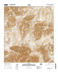
2016 Map of Howard Pass B-4 NW
USGS Topo · Published 2016About this map
Noatak National Preserve encompasses the southern portion of this Arctic quadrangle, where the high-altitude landscape is defined by the headwaters of several major drainage systems. In this wilderness area, the Kuna River flows north through the upper half of the map, carving a path through the steep, ridged topography of the North Slope. To the south and west, the terrain shifts toward the beginnings of the Utukok Cr and Makpik Creek, showing the complex hydrologic divide that characterizes this part of the Brooks Range foothills. The absence of roads or permanent settlements highlights the isolation of this region, where the preservation of natural waterways remains the primary geographical feature within the t11s r28w and t12s r27w townships.
Find a feature on this map
9 named features on this map. Tap any name to fly to it.
Don’t see what you’re looking for? This feature index may not catch every label — zoom into the map to look around manually.
Map Details
Editions of this 2016 Howard Pass B-4 NW Map
This is the sole edition of this map. No revisions or reprints were ever made.
Other maps of this area

1951 · Howard Pass
USGS Topo · 1:250,000

1956 · Howard Pass
USGS Topo · 1:250,000
1984 · Howard Pass C-5
USGS Topo · 1:63,360

1984 · Howard Pass B-4
USGS Topo · 1:63,360

1984 · Howard Pass C-4
USGS Topo · 1:63,360
1984 · Howard Pass B-5
USGS Topo · 1:63,360
2015 · Howard Pass B-5 SE
USGS Topo · 1:25,000
2015 · Howard Pass C-5 SE
USGS Topo · 1:25,000
2015 · Howard Pass B-5 NE
USGS Topo · 1:25,000
2015 · Howard Pass B-4 SW
USGS Topo · 1:25,000