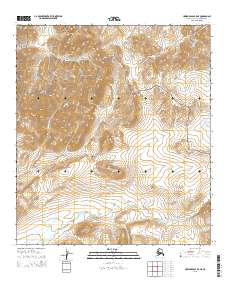
2015 Map of Howard Pass B-5 NE
USGS Topo · Published 2015About this map
The De Long Mountains anchor the western edge of this Arctic landscape, where the headwaters of several major drainages begin their descent. Much of the territory falls within the Noatak National Preserve, a designation that protects the undeveloped character of the watershed. The Kiligwa River flows through the northern reaches, while the Uivaksak Cr meanders across the southern plains, illustrating the complex hydrological network of the North Slope. Smaller tributaries like Wager Cr and Primus Cr carve through the high-elevation terrain, reflecting the seasonal flow patterns typical of this subarctic environment. The map provides a precise view of the topography before significant modern shifts in permafrost or drainage could alter these ancient watercourses.
Find a feature on this map
10 named features on this map. Tap any name to fly to it.
Don’t see what you’re looking for? This feature index may not catch every label — zoom into the map to look around manually.
Map Details
Editions of this 2015 Howard Pass B-5 NE Map
This is the sole edition of this map. No revisions or reprints were ever made.
Other maps of this area

1951 · Howard Pass
USGS Topo · 1:250,000

1956 · Howard Pass
USGS Topo · 1:250,000
1984 · Howard Pass C-5
USGS Topo · 1:63,360

1984 · Howard Pass B-4
USGS Topo · 1:63,360

1984 · Howard Pass C-4
USGS Topo · 1:63,360
1984 · Howard Pass B-5
USGS Topo · 1:63,360
2015 · Howard Pass B-5 SW
USGS Topo · 1:25,000
2015 · Howard Pass B-5 NW
USGS Topo · 1:25,000
2015 · Howard Pass B-5 SE
USGS Topo · 1:25,000
2015 · Howard Pass C-5 SE
USGS Topo · 1:25,000