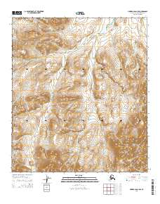
2015 Map of Howard Pass C-5 SE
USGS Topo · Published 2015About this map
Kiliguwa River flows through this portion of the North Slope, carving a central drainage basin in a landscape defined by sharp elevation shifts. The terrain is structured by a network of seasonal and perennial waterways including Drenchwater Cr in the northwest and Wager Cr to the southwest. This 2015 U.S. Geological Survey representation documents the hydrography and township boundaries across several ranges, such as t10s r29w and t10s r28w. The survey highlights a highly articulated topography where Twistem Cr maneuvers between steep ridges, illustrating the natural drainage patterns that dominate this sub-arctic environment.
Find a feature on this map
10 named features on this map. Tap any name to fly to it.
Don’t see what you’re looking for? This feature index may not catch every label — zoom into the map to look around manually.
Map Details
Editions of this 2015 Howard Pass C-5 SE Map
This is the sole edition of this map. No revisions or reprints were ever made.
Other maps of this area

1951 · Howard Pass
USGS Topo · 1:250,000

1956 · Howard Pass
USGS Topo · 1:250,000
1984 · Howard Pass C-5
USGS Topo · 1:63,360

1984 · Howard Pass B-4
USGS Topo · 1:63,360

1984 · Howard Pass C-4
USGS Topo · 1:63,360
1984 · Howard Pass B-5
USGS Topo · 1:63,360
2015 · Howard Pass B-5 NW
USGS Topo · 1:25,000
2015 · Howard Pass C-5 NW
USGS Topo · 1:25,000
2015 · Howard Pass B-5 NE
USGS Topo · 1:25,000
2015 · Howard Pass C-5 SW
USGS Topo · 1:25,000