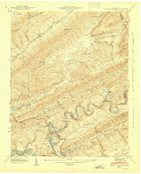
1943 Map of Howard Quarter
USGS Topo · Published 1946About this map
The Clinch River snakes through the center of this 1940s landscape, its winding course defining the sharp ridges and deep hollows of Claiborne, Grainger, and Hancock Counties. This era reflects the impact of the Tennessee Valley Authority’s engineering, as the rising waters of the Norris Reservoir reach into Condry Bend. The map documents a rural community structure defined by its schools and houses of worship, such as Howard Quarter Sch, Seal Chapel Sch, and Raven Hill Ch.
Find a feature on this map
80 named features on this map. Tap any name to fly to it.
Don’t see what you’re looking for? This feature index may not catch every label — zoom into the map to look around manually.
Map Details
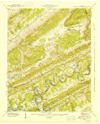
Editions of this 1943 Howard Quarter Map
2 editions found
Other maps of this area

1883 · Morristown
USGS Topo · 1:125,000

1886 · Cumberland Gap
USGS Topo · 1:125,000

1887 · Jonesville
USGS Topo · 1:125,000

1888 · Cumberland Gap
USGS Topo · 1:125,000

1891 · Cumberland Gap
USGS Topo · 1:125,000

1891 · Jonesville
USGS Topo · 1:125,000

1893 · Morristown
USGS Topo · 1:125,000

1895 · Morristown
USGS Topo · 1:125,000

1897 · Maynardville
USGS Topo · 1:125,000

1900 · Maynardville
USGS Topo · 1:125,000