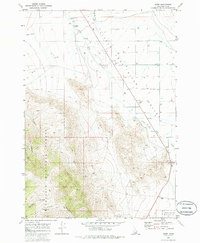
1969 Map of Howe
USGS Topo · Published 1986About this map
The Lost River Range dominates the western half of this Idaho survey, where the high peaks of the Challis National Forest meet the agricultural floor of the Little Lost River Valley. The landscape is defined by the transition from steep drainage systems like Jumpoff Canyon and Horsethief Canyon to the alluvial plain of the Little Lost River. This 1960s snapshot captures the small settlement of Howe at the edge of the mountains, showing its essential infrastructure including a Radio Tower and Substation.
Find a feature on this map
18 named features on this map. Tap any name to fly to it.
Don’t see what you’re looking for? This feature index may not catch every label — zoom into the map to look around manually.
Map Details
Editions of this 1969 Howe Map
2 editions found
Other maps of this area

1955 · Idaho Falls
USGS Topo · 1:250,000

1958 · Idaho Falls
USGS Topo · 1:250,000

1969 · Arco Pass
USGS Topo · 1:24,000

1969 · Little Lost River Sinks
USGS Topo · 1:24,000

1969 · Tyler Peak
USGS Topo · 1:24,000

1969 · Howe
USGS Topo · 1:24,000

1969 · Howe NW
USGS Topo · 1:24,000

1969 · Howe NE
USGS Topo · 1:24,000

1972 · Howe Peak
USGS Topo · 1:24,000

1972 · Arco Hills
USGS Topo · 1:24,000