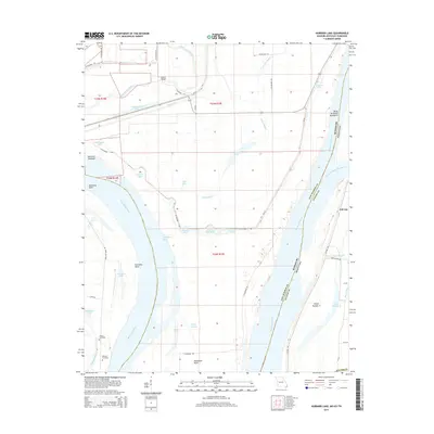
2015 Map of Hubbard Lake
USGS Topo · Published 2015About this map
Kentucky Bend defines this portion of the Mississippi River, where the state line between Missouri and Kentucky creates a unique geographic exclave. The landscape is dominated by the hydraulic history of the river, marked by numerous sloughs, chutes, and "holes" that indicate former river channels and flood patterns. Significant water bodies like Hubbard Lake, Fish Lake, and Stonewall Lake sit within the alluvial plain, surrounded by a network of drainage systems including Saint Johns Ditch and Mud Ditch. The presence of Adams Cemetery and Whitson Cemetery near the riverbanks provides valuable data points for genealogists tracking families in this river-bottom environment. The map also details early 21st-century infrastructure such as Kentucky Bend Rd and Co Highway 404, which navigate the complex terrain between the river's Hotchkiss Bend and the settlement at Ash Log.
Find a feature on this map
55 named features on this map. Tap any name to fly to it.
Don’t see what you’re looking for? This feature index may not catch every label — zoom into the map to look around manually.
Map Details
Editions of this 2015 Hubbard Lake Map
This is the sole edition of this map. No revisions or reprints were ever made.
Other maps of this area

1925 · Reelfoot Lake
USGS Topo · 1:62,500

1939 · Reelfoot Lake
USGS Topo · 1:62,500

1939 · Portageville
USGS Topo · 1:62,500

1939 · New Madrid
USGS Topo · 1:62,500

1939 · Bayouville
USGS Topo · 1:62,500

1951 · Bondurant
USGS Topo · 1:24,000

1951 · New Madrid SE
USGS Topo · 1:24,000

1951 · Hubbard Lake
USGS Topo · 1:24,000

1954 · New Madrid
USGS Topo · 1:62,500

1955 · Portageville
USGS Topo · 1:62,500