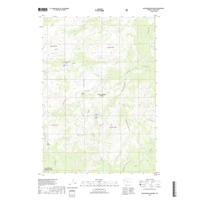
2017 Map of Huckleberry Mountain
USGS Topo · Published 2017About this map
Teton National Forest dominates this high-altitude landscape, where the northern boundaries of Grand Teton National Park meet the surrounding wilderness. The terrain is defined by a series of prominent rises and high meadows, most notably Huckleberry Mtn and its associated Huckleberry Ridge. To the south, Wildcat Peak and Wildcat Ridge rise above the drainage systems of Rodent Cr and Arizona Cr. A network of backcountry routes, including the Arizona Creek Trail and Colter Creek Trail, provides access through the heavily forested mountain slopes. These trails often follow the natural contours of the land, connecting open spaces like Brown Meadows and Bailey Meadows. The map illustrates the complex drainage patterns of the upper Teton region, where streams like Sheffield Cr and Pilgrim-Middle Pilgrim Creek carve through the deep valleys of the Teton and Bridger-Teton systems.
Find a feature on this map
29 named features on this map. Tap any name to fly to it.
Don’t see what you’re looking for? This feature index may not catch every label — zoom into the map to look around manually.
Map Details
Editions of this 2017 Huckleberry Mountain Map
This is the sole edition of this map. No revisions or reprints were ever made.
Other maps of this area

1885 · Lake
USGS Topo · 1:125,000

1886 · Shoshone
USGS Topo · 1:125,000

1888 · Shoshone
USGS Topo · 1:125,000

1895 · Shoshone
USGS Topo · 1:125,000

1895 · Lake
USGS Topo · 1:125,000

1896 · Lake
USGS Topo · 1:125,000

1899 · Grand Teton
USGS Topo · 1:125,000

1901 · Shoshone
USGS Topo · 1:125,000

1901 · Lake
USGS Topo · 1:125,000

1901 · Grand Teton
USGS Topo · 1:125,000