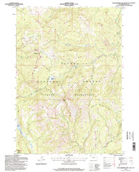
1996 Map of Huckleberry Mountain
USGS Topo · Published 1998About this map
Huckleberry Mountain and the surrounding Teton National Forest dominate this high-altitude landscape in the mid-1990s. The map details a complex network of ridgelines and drainages, where Huckleberry Ridge and Wildcat Ridge form the spine of the territory. This area is characterized by its transition from managed forest land into the protected boundaries of the Teton Wilderness and a northern corner of Grand Teton National Park.
Find a feature on this map
26 named features on this map. Tap any name to fly to it.
Don’t see what you’re looking for? This feature index may not catch every label — zoom into the map to look around manually.
Map Details
Editions of this 1996 Huckleberry Mountain Map
This is the sole edition of this map. No revisions or reprints were ever made.
Other maps of this area

1885 · Lake
USGS Topo · 1:125,000

1886 · Shoshone
USGS Topo · 1:125,000

1888 · Shoshone
USGS Topo · 1:125,000

1895 · Shoshone
USGS Topo · 1:125,000

1895 · Lake
USGS Topo · 1:125,000

1896 · Lake
USGS Topo · 1:125,000

1899 · Grand Teton
USGS Topo · 1:125,000

1901 · Shoshone
USGS Topo · 1:125,000

1901 · Lake
USGS Topo · 1:125,000

1901 · Grand Teton
USGS Topo · 1:125,000