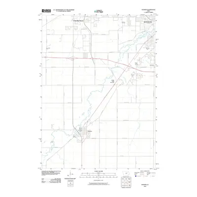
2010 Map of Hudson
USGS Topo · Published 2010About this map
Black Hawk Creek meanders through this portion of Black Hawk County, connecting the southern rural landscapes with the expanding fringes of Cedar Falls and Waterloo. The town of Hudson serves as a primary focal point, showing a developed street grid anchored by the Hudson Post Office and nearby Hudson Cemetery. The map reflects a landscape transitioning from agricultural use to suburban and recreational spaces, evidenced by the presence of Beech Nut Golf Course and Sunnyside Golf Course. Transportation corridors like Eldora Rd and Dale Dr facilitate movement between these growing communities. Several notable memorial sites are documented, including Waterloo Memorial Park, Mount Olivet Cemetery, and the Pet Haven Cemetery, providing valuable points of reference for local historians and genealogists tracking family plots in the Cedar Valley region.
Find a feature on this map
49 named features on this map. Tap any name to fly to it.
Don’t see what you’re looking for? This feature index may not catch every label — zoom into the map to look around manually.
Map Details
Editions of this 2010 Hudson Map
This is the sole edition of this map. No revisions or reprints were ever made.
Other maps of this area

1954 · Waterloo
USGS Topo · 1:250,000

1955 · Waterloo
USGS Topo · 1:250,000

1963 · Buckingham
USGS Topo · 1:24,000

1963 · Hudson
USGS Topo · 1:24,000

1963 · Waterloo South
USGS Topo · 1:24,000

1963 · Eagle Center
USGS Topo · 1:24,000

1963 · Cedar Falls
USGS Topo · 1:24,000

1963 · Waterloo North
USGS Topo · 1:24,000

1971 · Zaneta
USGS Topo · 1:24,000

1971 · Reinbeck
USGS Topo · 1:24,000