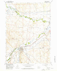
1957 Map of Hudson
USGS Topo · Published 1976About this map
The Wind River Indian Reservation dominates the landscape of this mid-century Fremont County survey, where the convergence of the Popo Agie River and the Little Wind River dictates the region's agricultural and transit corridors. The town of Hudson serves as a central hub, situated at the junction of the Chicago and North Western railroad and the Little Popo Agie River. Extensive irrigation infrastructure, such as the Sub-Agency Ditch and Sharp Nose Drain, reveals the effort required to manage water in the Wyoming valley. Beyond the settlement, the Hudson Railroad Grade and several Gravel Pits point to the industrial and logistical needs of the era. Rare recreational markers like the Racetrack and the local City Dump provide specific points of interest for local historians and genealogists tracing the physical layout of the community as it functioned in the late 1950s.
Find a feature on this map
25 named features on this map. Tap any name to fly to it.
Don’t see what you’re looking for? This feature index may not catch every label — zoom into the map to look around manually.
Map Details
Editions of this 1957 Hudson Map
3 editions found
Other maps of this area

1951 · Mule Butte
USGS Topo · 1:24,000

1951 · Pavillion SE
USGS Topo · 1:24,000

1951 · Riverton West
USGS Topo · 1:24,000

1952 · Hudson
USGS Topo · 1:24,000

1952 · Lander SE
USGS Topo · 1:24,000

1952 · Lander
USGS Topo · 1:24,000

1952 · Lander NW
USGS Topo · 1:24,000

1953 · Ninemile Hill
USGS Topo · 1:24,000

1953 · Arapahoe
USGS Topo · 1:24,000

1955 · Thermopolis
USGS Topo · 1:250,000