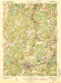
1943 Map of Hudson
USGS Topo · Published 1943About this map
Hudson and the surrounding townships of Bolton and Stow are captured here during the early 1940s, revealing a landscape defined by small-town centers and institutional landmarks. The Assabet River flows through the industrial heart of Hudson, where the grid of streets includes the Broad Street Sch and Main Street Cem. Higher ground to the north features educational and social anchors like Bromfield Academy near Harvard and several numbered schoolhouses in Boxboro.
Find a feature on this map
83 named features on this map. Tap any name to fly to it.
Don’t see what you’re looking for? This feature index may not catch every label — zoom into the map to look around manually.
Map Details
Editions of this 1943 Hudson Map
4 editions found
Other maps of this area

1886 · Lowell
USGS Topo · 1:62,500

1886 · Framingham
USGS Topo · 1:62,500

1887 · Marlboro
USGS Topo · 1:62,500

1889 · Marlboro
USGS Topo · 1:62,500

1889 · Framingham
USGS Topo · 1:62,500

1893 · Lowell
USGS Topo · 1:62,500

1893 · Groton
USGS Topo · 1:62,500

1894 · Framingham
USGS Topo · 1:62,500

1896 · Marlboro
USGS Topo · 1:62,500

1898 · Marlboro
USGS Topo · 1:62,500