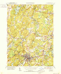
1943 Map of Hudson
USGS Topo · Published 1952About this map
The industrial and agricultural center of Hudson is captured here as it stood in the mid-20th century, dominated by its dense street grid and the Boston and Maine Railroad. The Assabet River winds through the region, powering the historical development of settlements like Gleasondale and South Bolton. This survey reveals a landscape deeply connected to its educational and spiritual roots, featuring Bromfield Academy in the north and the Old Quaker Ch to the west. Local genealogy is well-represented through numerous burial grounds, including the Friends Cem and Bellevue Cem. Beyond the town centers, the terrain is defined by prominent elevations like Rattlesnake Hill and recreational sites such as Camp Resolute on the shores of Little Pond. The map serves as a detailed record of the borderlands between Worcester and Middlesex counties.
Find a feature on this map
124 named features on this map. Tap any name to fly to it.
Don’t see what you’re looking for? This feature index may not catch every label — zoom into the map to look around manually.
Map Details
Editions of this 1943 Hudson Map
4 editions found
Other maps of this area

1886 · Lowell
USGS Topo · 1:62,500

1886 · Framingham
USGS Topo · 1:62,500

1887 · Marlboro
USGS Topo · 1:62,500

1889 · Marlboro
USGS Topo · 1:62,500

1889 · Framingham
USGS Topo · 1:62,500

1893 · Lowell
USGS Topo · 1:62,500

1893 · Groton
USGS Topo · 1:62,500

1894 · Framingham
USGS Topo · 1:62,500

1896 · Marlboro
USGS Topo · 1:62,500

1898 · Marlboro
USGS Topo · 1:62,500