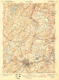
1943 Map of Hudson
USGS Topo · Published 1943About this map
The industrial and educational landscape of Middlesex County is centered on the Hudson township and the winding Assabet River. This 1940s-era documentation captures the transition from rural crossroads like Brockway Corner and Browns Corner to the more developed centers of Stow and Bolton. Local history researchers will find a dense network of numbered school districts, such as School No 1 through School No 4, alongside institutions like the Bromfield Academy.
Find a feature on this map
84 named features on this map. Tap any name to fly to it.
Don’t see what you’re looking for? This feature index may not catch every label — zoom into the map to look around manually.
Map Details
Editions of this 1943 Hudson Map
4 editions found
Other maps of this area

1886 · Lowell
USGS Topo · 1:62,500

1886 · Framingham
USGS Topo · 1:62,500

1887 · Marlboro
USGS Topo · 1:62,500

1889 · Marlboro
USGS Topo · 1:62,500

1889 · Framingham
USGS Topo · 1:62,500

1893 · Lowell
USGS Topo · 1:62,500

1893 · Groton
USGS Topo · 1:62,500

1894 · Framingham
USGS Topo · 1:62,500

1896 · Marlboro
USGS Topo · 1:62,500

1898 · Marlboro
USGS Topo · 1:62,500