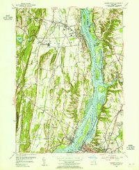
1953 Map of Hudson North
USGS Topo · Published 1955About this map
The Hudson River serves as the central artery for this mid-century portrait of the Hudson Valley, separating Greene and Columbia counties. On the western bank, the village of Coxsackie and the State Vocational Institution sit amidst a complex network of drainage, including Murderers Creek and Coxsackie Creek. The river itself is filled with navigational hazards and landmarks such as the Middle Ground Flats, Bogardus Island, and the Lighthouse near Athens. Industrial and institutional footprints are prominent, from the New York Central railroad lines hugging the banks to the Coxsackie-Athens Central School. On the eastern shore, smaller settlements like Newton Hook and Stottville are situated near the confluence of Stockport Creek and the river, showing the persistent late-industrial character of the valley before modern highway expansion fully reshaped the local geography.
Find a feature on this map
59 named features on this map. Tap any name to fly to it.
Don’t see what you’re looking for? This feature index may not catch every label — zoom into the map to look around manually.
Map Details
Editions of this 1953 Hudson North Map
3 editions found
Other maps of this area

1893 · Coxsackie
USGS Topo · 1:62,500

1894 · Coxsackie
USGS Topo · 1:62,500

1895 · Catskill
USGS Topo · 1:62,500

1902 · Copake
USGS Topo · 1:62,500

1903 · Kinderhook
USGS Topo · 1:62,500

1904 · Copake
USGS Topo · 1:62,500

1929 · Coxsackie
USGS Topo · 1:62,500

1933 · Kinderhook
USGS Topo · 1:62,500

1934 · Catskill
USGS Topo · 1:62,500

1938 · Catskill
USGS Topo · 1:62,500