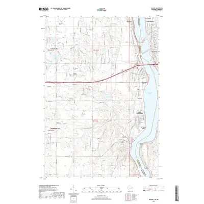
2019 Map of Hudson
USGS Topo · Published 2019About this map
Lake Saint Croix forms a dramatic aquatic border between Minnesota and Wisconsin, defining the character of the riverfront communities on this 2019 survey. The eastern shore is anchored by Hudson and North Hudson, while the western banks are lined with a sequence of residential enclaves including Lakeland, Lake St. Croix Beach, and St. Marys Point. Inland, the terrain is shaped by glacial legacy, featuring numerous small bodies of water like Horseshoe Lake and Sunfish Lake, alongside significant cultural markers such as Bissels Mounds. The area's spiritual and genealogical history is exceptionally well-documented through a dense concentration of burial sites, ranging from the Old Trinity Evangelical Lutheran Cem and Saint Paulus Lutheran Cem to the family-named Fahlstrom Cem. These sites, along with landmarks like Walker Field, illustrate the transition from rural township life to suburban riverfront development.
Find a feature on this map
48 named features on this map. Tap any name to fly to it.
Don’t see what you’re looking for? This feature index may not catch every label — zoom into the map to look around manually.
Map Details
Editions of this 2019 Hudson Map
This is the sole edition of this map. No revisions or reprints were ever made.
Other maps of this area

1946 · Hudson
USGS Topo · 1:62,500

1946 · River Falls
USGS Topo · 1:62,500

1948 · New Richmond
USGS Topo · 1:62,500

1948 · Stillwater
USGS Topo · 1:62,500

1949 · New Richmond
USGS Topo · 1:62,500

1949 · River Falls
USGS Topo · 1:62,500

1949 · Hudson
USGS Topo · 1:62,500

1949 · Stillwater
USGS Topo · 1:62,500

1949 · Lake Elmo
USGS Topo · 1:24,000

1949 · Hudson
USGS Topo · 1:24,000