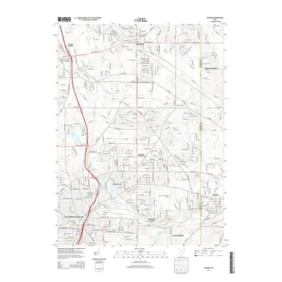
2013 Map of Hudson
USGS Topo · Published 2013About this map
Hudson serves as the focal point of this study, positioned near the junction of several established communities in the early 21st century. The landscape is defined by the headwaters and tributaries of the Cuyahoga River, including Powers Brook and Mud Brook, which carve through the terrain. Evidence of the region’s long-standing settlement is found in several pioneer-era burial sites, most notably the Old Hudson Township Burying Ground and the O'Brien Cem. The western edge of the area is preserved by the Cuyahoga Valley National Park, offering a clear boundary to the suburban expansion seen in Stow, Silver Lake, and Cuyahoga Falls. In the southeast, the Kent State University Airport and the outskirts of Kent mark the transition toward more industrial and academic centers, while numerous small lakes like Lake Forest and Wyoga Lake characterize the local drainage patterns.
Find a feature on this map
144 named features on this map. Tap any name to fly to it.
Don’t see what you’re looking for? This feature index may not catch every label — zoom into the map to look around manually.
Map Details
Editions of this 2013 Hudson Map
This is the sole edition of this map. No revisions or reprints were ever made.
Other maps of this area

1903 · Cleveland
USGS Topo · 1:62,500

1903 · Akron
USGS Topo · 1:62,500

1905 · Akron
USGS Topo · 1:62,500

1906 · Kent
USGS Topo · 1:62,500

1906 · Chagrin Falls
USGS Topo · 1:62,500

1908 · Chagrin Falls
USGS Topo · 1:62,500

1950 · Cleveland
USGS Topo · 1:250,000

1953 · Aurora
USGS Topo · 1:24,000

1953 · Twinsburg
USGS Topo · 1:24,000
1953 · Northfield
USGS Topo · 1:24,000