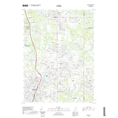
2019 Map of Hudson
USGS Topo · Published 2019About this map
Hudson and the surrounding suburbs of Akron reveal a landscape deeply shaped by the Cuyahoga River and a dense network of local cemeteries and community institutions. This 2019 survey captures the developed character of northern Summit County, where the historic Old Hudson Township-Burying Ground Cem and Markillie Cem stand alongside modern landmarks like Kent State University Airport. The western edge of the sheet is dominated by the Cuyahoga Valley National Park, preserving a corridor of natural terrain amidst the growing residential footprints of Stow and Cuyahoga Falls. Traces of the region's commercial infrastructure remain visible through the Wheeling & Lake Erie RR corridor, which connects these established communities. Water features such as Silver Lake, Wyoga Lake, and Crystal Lake provide focal points for local neighborhoods, illustrating the shift from a rural township past to a modern suburban residential corridor.
Find a feature on this map
69 named features on this map. Tap any name to fly to it.
Don’t see what you’re looking for? This feature index may not catch every label — zoom into the map to look around manually.
Map Details
Editions of this 2019 Hudson Map
This is the sole edition of this map. No revisions or reprints were ever made.
Other maps of this area

1903 · Cleveland
USGS Topo · 1:62,500

1903 · Akron
USGS Topo · 1:62,500

1905 · Akron
USGS Topo · 1:62,500

1906 · Kent
USGS Topo · 1:62,500

1906 · Chagrin Falls
USGS Topo · 1:62,500

1908 · Chagrin Falls
USGS Topo · 1:62,500

1950 · Cleveland
USGS Topo · 1:250,000

1953 · Aurora
USGS Topo · 1:24,000

1953 · Twinsburg
USGS Topo · 1:24,000
1953 · Northfield
USGS Topo · 1:24,000