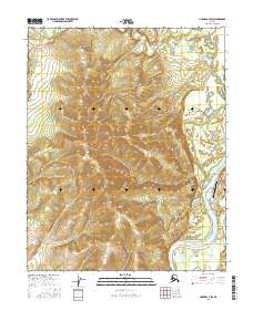
2016 Map of Hughes A-3 SW
USGS Topo · Published 2016About this map
The Koyukuk River bends sharply through this interior Alaskan landscape, anchoring the village of Hughes. This 2016 survey documents the small settlement's footprint on the riverbank, including its aviation lifeline at the Hughes Airport. Local infrastructure is concentrated in the village's immediate vicinity, where residential paths like Blueberry Lane and Hillside Road meet the wilderness edge.
Find a feature on this map
13 named features on this map. Tap any name to fly to it.
Don’t see what you’re looking for? This feature index may not catch every label — zoom into the map to look around manually.
Map Details
Editions of this 2016 Hughes A-3 SW Map
This is the sole edition of this map. No revisions or reprints were ever made.
Other maps of this area

1951 · Hughes
USGS Topo · 1:250,000

1951 · Melozitna
USGS Topo · 1:250,000

1952 · Melozitna D-3
USGS Topo · 1:63,360

1954 · Melozitna D-4
USGS Topo · 1:63,360

1954 · Melozitna D-3
USGS Topo · 1:63,360

1955 · Hughes A-3
USGS Topo · 1:63,360

1956 · Hughes
USGS Topo · 1:250,000

1956 · Melozitna
USGS Topo · 1:250,000
1956 · Hughes A-3
USGS Topo · 1:63,360

1964 · Hughes
USGS Topo · 1:250,000