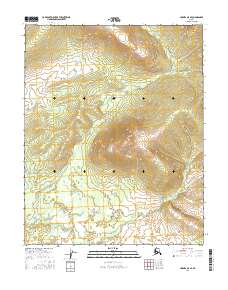
2016 Map of Hughes A-5 SE
USGS Topo · Published 2016About this map
Round Mtn dominates the central landscape of this interior Alaska quadrangle, providing a significant topographical anchor in the Yukon-Koyukuk region. The surrounding terrain is defined by the drainage patterns of McLanes Cr, which winds through the valleys between the prominent heights of the Round Mtn massif and the outlying ridges. This 2016 survey illustrates a largely untouched wilderness within the Public Land Survey System townships of t8n r17e, t8n r18e, t7n r17e, and t7n r18e. The map reflects the complex hydrography of the Alaskan interior, showing a network of small tributaries and wetlands that feed into the larger creek system, characteristic of the remote northern wilderness before any significant modern infrastructure or settlement development.
Find a feature on this map
6 named features on this map. Tap any name to fly to it.
Don’t see what you’re looking for? This feature index may not catch every label — zoom into the map to look around manually.
Map Details
Editions of this 2016 Hughes A-5 SE Map
This is the sole edition of this map. No revisions or reprints were ever made.
Other maps of this area

1951 · Hughes
USGS Topo · 1:250,000

1951 · Melozitna
USGS Topo · 1:250,000

1954 · Melozitna D-5
USGS Topo · 1:63,360

1954 · Melozitna D-4
USGS Topo · 1:63,360

1956 · Hughes
USGS Topo · 1:250,000

1956 · Melozitna
USGS Topo · 1:250,000

1964 · Hughes
USGS Topo · 1:250,000

1965 · Hughes
USGS Topo · 1:250,000
1986 · Hughes A-5
USGS Topo · 1:63,360
1986 · Hughes A-4
USGS Topo · 1:63,360