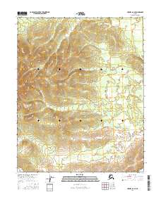
2016 Map of Hughes A-6 SE
USGS Topo · Published 2016About this map
Hogatzakhotak Creek and First Creek define the drainage patterns of this interior Alaskan landscape within the Yukon-Koyukuk region. This 2016 survey, produced by the U.S. Geological Survey, meticulously documents the complex topography and public land survey system divisions. The map highlights the intersection of several townships, including t8n r15e, t8n r16e, t7n r15e, and t7n r16e, providing a precise record of boundary lines across the undeveloped terrain. This documentation is essential for understanding land management and natural waterway courses in a region defined by its hydrography rather than human settlement.
Find a feature on this map
6 named features on this map. Tap any name to fly to it.
Don’t see what you’re looking for? This feature index may not catch every label — zoom into the map to look around manually.
Map Details
Editions of this 2016 Hughes A-6 SE Map
This is the sole edition of this map. No revisions or reprints were ever made.
Other maps of this area

1951 · Hughes
USGS Topo · 1:250,000

1951 · Melozitna
USGS Topo · 1:250,000

1954 · Melozitna D-5
USGS Topo · 1:63,360

1954 · Melozitna D-6
USGS Topo · 1:63,360

1956 · Hughes
USGS Topo · 1:250,000

1956 · Melozitna
USGS Topo · 1:250,000

1964 · Hughes
USGS Topo · 1:250,000

1965 · Hughes
USGS Topo · 1:250,000
1986 · Hughes A-6
USGS Topo · 1:63,360
1986 · Hughes A-5
USGS Topo · 1:63,360