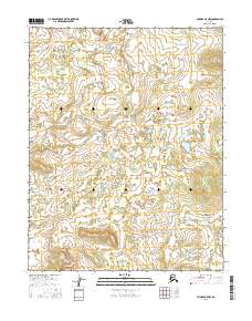
2016 Map of Hughes B-5 NW
USGS Topo · Published 2016About this map
Pah River winds through the wetlands and rolling high ground of this interior Alaska wilderness, as documented in a 2016 survey. The terrain is defined by the Continental Divide, which separates the drainage systems in the northeastern portion of the map. Historically, the Totzititi Portage represents a critical overland route between watersheds, indicating the seasonal movement and transportation patterns used in this subarctic landscape. The map shows a vast network of unnamed ponds and marshes characteristic of the region's hydrography, alongside several township boundaries including t13n r16e and t12n r17e that delineate the public land survey system in this unpopulated reach of the Yukon-Koyukuk region.
Find a feature on this map
9 named features on this map. Tap any name to fly to it.
Don’t see what you’re looking for? This feature index may not catch every label — zoom into the map to look around manually.
Map Details
Editions of this 2016 Hughes B-5 NW Map
This is the sole edition of this map. No revisions or reprints were ever made.
Other maps of this area

1951 · Hughes
USGS Topo · 1:250,000

1956 · Hughes
USGS Topo · 1:250,000

1964 · Hughes
USGS Topo · 1:250,000

1965 · Hughes
USGS Topo · 1:250,000
1986 · Hughes B-5
USGS Topo · 1:63,360
1986 · Hughes B-6
USGS Topo · 1:63,360
1986 · Hughes C-5
USGS Topo · 1:63,360
1986 · Hughes C-6
USGS Topo · 1:63,360
2016 · Hughes B-6 SE
USGS Topo · 1:25,000
2016 · Hughes B-6 NE
USGS Topo · 1:25,000