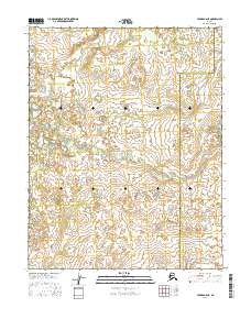
2016 Map of Hughes B-6 NE
USGS Topo · Published 2016About this map
Totzitigi Portage stands as a significant historical landmark in this northern interior landscape, representing an ancient overland route between river systems. The map details the drainage patterns of the Pah River and its tributaries, including Holly Cr and Asiksak Cr, within the transition zone between the Northwest Arctic Borough and the Yukon-Koyukuk Census Area. Produced in 2016 using GNIS names and National Hydrography Dataset information, the sheet reveals a remote landscape where the lack of modern road infrastructure emphasizes the historic importance of the portage and river corridors for travel across the Alaskan interior.
Find a feature on this map
12 named features on this map. Tap any name to fly to it.
Don’t see what you’re looking for? This feature index may not catch every label — zoom into the map to look around manually.
Map Details
Editions of this 2016 Hughes B-6 NE Map
This is the sole edition of this map. No revisions or reprints were ever made.
Other maps of this area

1951 · Hughes
USGS Topo · 1:250,000

1956 · Hughes
USGS Topo · 1:250,000

1964 · Hughes
USGS Topo · 1:250,000

1965 · Hughes
USGS Topo · 1:250,000
1986 · Hughes B-5
USGS Topo · 1:63,360
1986 · Hughes B-6
USGS Topo · 1:63,360
1986 · Hughes C-5
USGS Topo · 1:63,360
1986 · Hughes C-6
USGS Topo · 1:63,360
2016 · Hughes B-6 SE
USGS Topo · 1:25,000
2016 · Hughes B-5 NW
USGS Topo · 1:25,000