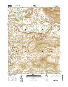
2016 Map of Hughes C-1 NW
USGS Topo · Published 2016About this map
The Alatna River meanders through this interior Alaskan landscape, defining a complex network of oxbow lakes and wetlands. This 2016 survey documents the intricate fluvial morphology of the river valley, where the water's path creates a high-density wetland environment characteristic of the Yukon-Koyukuk region. To the south and west, the terrain rises away from the floodplain as mapped by the course of Siruk Creek. Further south, the map identifies the headwaters and drainage of Henry Cr. The landscape is largely defined by the Public Land Survey System grids, including t15n r25e and t16n r26e, which mark this vast, unpopulated wilderness before it reaches more established outposts. The lack of named roads or structures underscores the area's isolation, serving as a primary record of the natural hydrography and elevation in this part of the Brooks Range foothills.
Find a feature on this map
9 named features on this map. Tap any name to fly to it.
Don’t see what you’re looking for? This feature index may not catch every label — zoom into the map to look around manually.
Map Details
Editions of this 2016 Hughes C-1 NW Map
This is the sole edition of this map. No revisions or reprints were ever made.
Other maps of this area

1951 · Hughes
USGS Topo · 1:250,000

1956 · Hughes
USGS Topo · 1:250,000

1964 · Hughes
USGS Topo · 1:250,000

1965 · Hughes
USGS Topo · 1:250,000
1986 · Hughes D-1
USGS Topo · 1:63,360
1986 · Hughes D-2
USGS Topo · 1:63,360
1986 · Hughes C-1
USGS Topo · 1:63,360
1986 · Hughes C-2
USGS Topo · 1:63,360
2016 · Hughes C-2 NE
USGS Topo · 1:25,000
2016 · Hughes C-1 SW
USGS Topo · 1:25,000